




DJI Modify
DJI Modify is DJI’s first intelligent 3D model editing software. It repairs floating elements, holes and vehicles in 3D meshes with a single click, generates realistic textures and allows point clouds to be smoothed, classified and edited efficiently. Integrated with DJI Terra and DJI Enterprise drones, it completes the workflow from aerial data capture to model delivery, including direct cloud sharing.
- Intelligent 3D mesh editing with one-click repair
- Point cloud classification and cleaning with smart filters
- Seamless workflow with DJI Terra version 4.0.0 or later
- Export in multiple formats: OSGB, B3DM, OBJ, PLY, LAS and S3MB
- Cloud model sharing via link
Request more information
DJI Modify: intelligent 3D model editing software
DJI Modify is DJI’s 3D model editing software, developed to complete drone photogrammetry workflows. Designed with a simple and intuitive interface, it allows users to edit three-dimensional models and point clouds quickly, without requiring advanced modelling software skills. It automatically identifies common defects in photogrammetry-generated models, such as floating elements, mesh holes and vehicles, and repairs them with a single click while generating realistic textures.
Combined with DJI Enterprise drones and DJI Terra processing software, DJI Modify forms a complete solution covering the entire workflow: aerial data capture, 3D reconstruction, model editing and final delivery. It is an ideal tool for surveying, mapping, construction, emergency response and infrastructure inspection professionals.
Main DJI Modify features
One-click 3D mesh editing
DJI Modify automatically detects the most common defects in photogrammetric 3D models and corrects them efficiently:
- Removal of floating elements from the model
- Filling of mesh holes, including gaps between adjacent blocks
- Vehicle recognition and removal
- Surface flattening and water surface repair
- Rapid generation of realistic textures from aerial triangulation images
The software works simultaneously with high-quality models (PLY, OBJ) for detailed adjustments and low-quality models (B3DM, OSGB) for editing large areas, synchronising changes between both through rendering.
Point cloud editing and classification
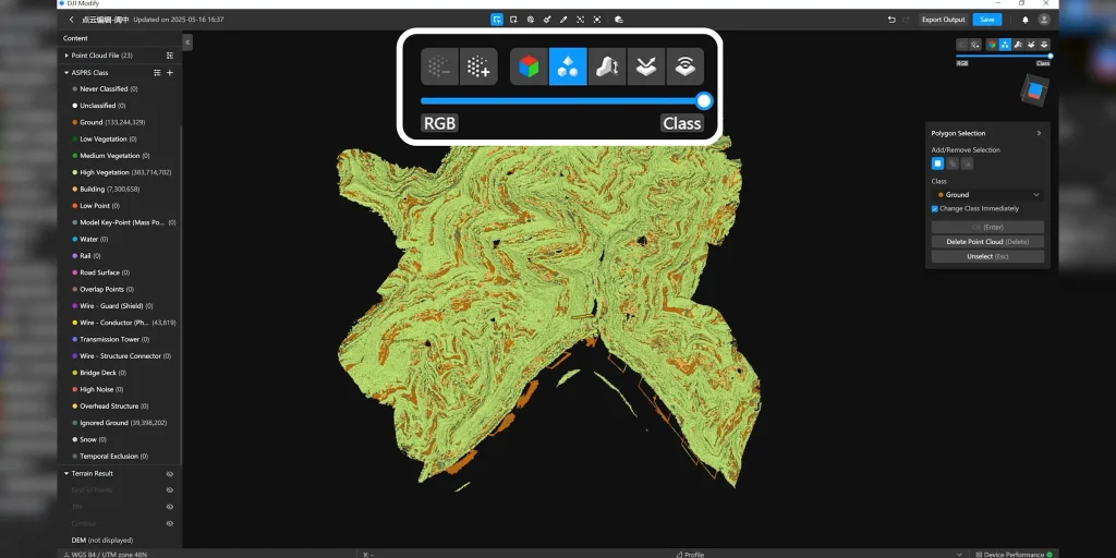
DJI Modify includes advanced tools for processing LiDAR and photogrammetric point clouds:
- Point cloud smoothing, noise reduction and downsampling
- Smart Filter with automatic classification according to ASPRS categories: ground, vegetation, buildings, power lines, towers, vehicles and dynamic objects
- Ground filter for rapid extraction of ground points
- Smart selection by structure (ground, roofs, vertical surfaces, cables and poles) and by colour, with adjustable tolerance
- Automatic generation of terrain results, including TIN models coloured by elevation
- Profile view for precise editing
It supports the import of LAS files containing up to 4.2 billion points and export in LAS 1.2, LAS 1.4, PNTS, PLY, PCD and S3MB formats.
Integrated workflow with DJI Terra
DJI Modify directly edits visible-light 3D models reconstructed with DJI Terra version 4.0.0 or later, without requiring intermediate conversions. The complete workflow with DJI Enterprise drones therefore remains within the DJI ecosystem: flight planning, data capture, reconstruction in DJI Terra, editing in DJI Modify and delivery of the final result.
Cloud collaboration and rapid delivery
Edited models can be uploaded to the DJI cloud and shared via a link, streamlining delivery to customers and project teams. For security purposes, coordinate information is removed before uploading. Local export is available in B3DM, OSGB, PLY, OBJ and S3MB formats while preserving the project’s original coordinate system.
Professional applications
- Surveying and mapping: clean 3D models ready for delivery
- Construction and BIM: construction progress documentation and earthwork calculations
- Emergency response and public safety: updated models of affected areas
- Infrastructure and transport inspection
- Heritage: digitisation and refinement of historic building models
System requirements
Minimum requirements
- Windows 10 or later (64-bit)
- 32 GB RAM
- NVIDIA graphics card with compute capability 6.1 or higher, 4 GB of graphics memory and performance equivalent to or greater than a GeForce GTX 1050 Ti
- NVIDIA driver version 522.25 or later
Recommended requirements
- Windows 10 or later (64-bit)
- 64 GB RAM
- NVIDIA graphics card with compute capability 7.0 or higher, 8 GB of graphics memory and performance equivalent to or greater than a GeForce RTX 2070
DJI Modify is not compatible with macOS or AMD graphics cards. It requires a permanent internet connection because it operates with a network licence. Point cloud editing capacity depends on the available RAM: systems with 32 GB can edit point clouds of up to 15 GB, systems with 64 GB up to 30 GB and systems with 128 GB up to 60 GB.
Licensing and purchase in Spain
DJI Modify is sold through authorised DJI Enterprise distributors. The paid licence allows the device to be unbound: once per year for single-device licences and twice per year for multi-device licences. At Global Geosystems, an official DJI Enterprise distributor in Spain and Portugal, we can advise you on the licence best suited to your workflow and provide technical support and training.