
DJI Terra
DJI Terra 3D model digitisation and reconstruction software.
Designed to work in harmony with DJI Enterprise drones and instruments, DJI Terra becomes the ideal complete solution for various applications, such as surveying, terrain mapping, power transmission, emergency services, construction, transport, and agriculture.
Request more information
3D Model Optimisation with DJI Terra: Revolutionise Mapping and Surveying
Discover DJI Terra, the leading 3D model reconstruction software that uses photogrammetry as its core technology. This powerful programme offers precise and efficient 2D and 3D reconstructions, leveraging visible light and data processing through DJI's advanced LiDAR technology.
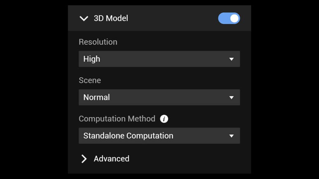
Generating Realistic 3D Models with DJI Terra
Experience the revolution in mapping and 3D models with DJI Terra. With our advanced technology, you can generate realistic 3D models in three different resolutions: high, medium, and low. Automatic optimisation using artificial intelligence ensures that water surfaces in your models are flawless.
DJI Terra goes further by exporting formats widely used in the industry, ideal for image reconstruction in various scenarios. Whether for surveying, mapping, accident site analysis, power grid equipment inspection, or tracking progress in construction projects, DJI Terra offers you the perfect tool. Discover the power of 3D model generation with DJI Terra and raise the quality of your projects to new levels.
Scale | 400 photos/ 1 GB (stand-alone computer) 6,000 photos/ 1 GB (cluster processing) |
Efficiency | 30,000 photos/ 3 days (stand-alone computer) 30,000 sheets/ 21 hours (cluster processing) |
Precision | Centimetre-level precision |
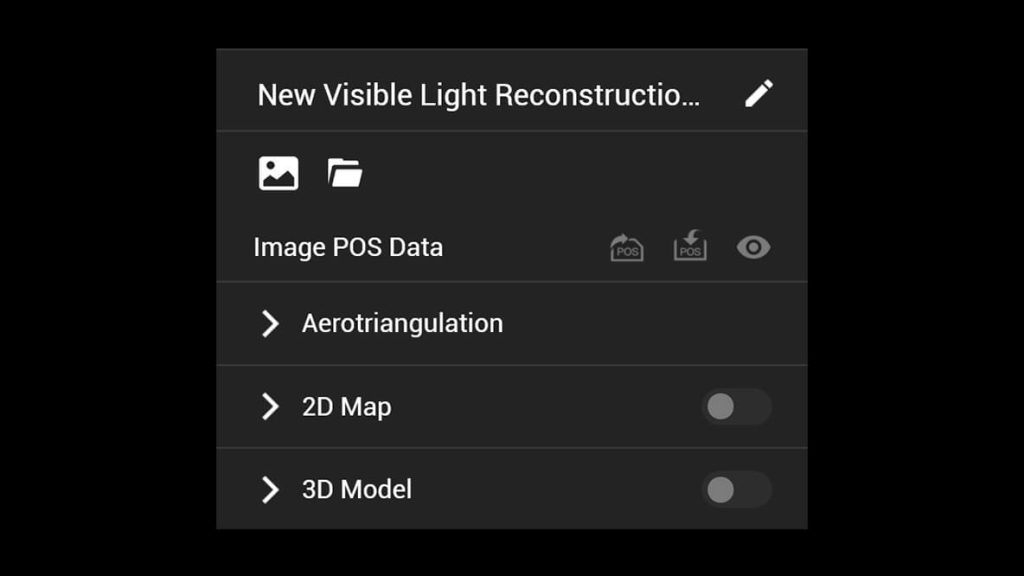
Perfection in 2D Maps with DJI Terra
In the world of 2D maps, DJI Terra stands out by optimising its algorithm according to various scenarios, achieving a significant improvement in processing efficiency. This approach not only ensures effective prevention of image distortion and deformation but also offers detailed and precise measurement results for all target objects and study areas.
Discover how DJI Terra elevates the quality of 2D map generation, providing a tool that perfectly adapts to your needs. Optimise your processes, avoid distortions, and obtain precise measurements in every project. With DJI Terra, excellence in 2D mapping is within your reach.
Scale | 400 photos/ 1 GB (stand-alone computer) 6,000 sheets/ 1 GB (cluster processing) |
Efficiency | 5,000 photos/ 2 days (stand-alone computer) 5,000 sheets/ 80 minutes (cluster processing) |
Precision | Centimetre-level precision |
Efficient LiDAR with One Click
DJI Terra simplifies the information processing of point clouds captured by Zenmuse LiDAR with just one click. From route calculation to the precise fusion of point cloud and visible light data, DJI Terra efficiently handles point cloud accuracy optimisation.
With advanced features such as ground point extraction, Digital Elevation Model (DEM) generation, and detailed mission report creation, DJI Terra becomes the essential tool to get the most out of your LiDAR data. Discover the ease and precision with which DJI Terra performs LiDAR processing, taking your capabilities to new heights with just one click.
Revolutionise Agriculture with DJI Terra and Multispectral Data
DJI Terra makes the most of multispectral data from the DJI Mavic 3 Multispectral and P4 Multispectral to provide you with a detailed view of plant growth and health. With the ability to generate vegetation index maps, including NDVI and NDRE, it provides crucial information for agricultural decision-making.
This software is compatible with radiometric correction and allows for the creation of reflectance maps, facilitating remote sensing research. Furthermore, DJI Terra gives you the ability to create prescription maps for variable rate applications with DJI Agras drones, improving yields and reducing costs. Discover how DJI Terra and multispectral data are transforming agriculture efficiently and profitably.
Other Notable Features
Real-time 3D Mapping | In situations where efficiency is crucial, DJI Terra allows you to quickly generate and visualise a 3D model of the mapped area in real-time. This gives you the ability to make informed decisions with a preliminary model, immediately verify mission progress, and plan 3D flights on-site. Discover the agility of real-time 3D mapping with DJI Terra, providing a powerful tool for situations where speed and instant decision-making are key. Simplify your processes, increase efficiency, and take control of your operations with DJI Terra's unique ability to generate 3D models in real-time. |
Real-time Mapping | DJI Terra allows you to instantly generate a 2D orthomosaic of the selected area in real-time, offering a perfect tool for creating detailed flight routes in remote locations. Its utility extends to missions where time is of the essence and on-site decisions must be made quickly. Discover the effectiveness of real-time mapping with DJI Terra, allowing you not only to immediately visualise mapping information but also to make informed decisions on the go. Streamline your operations, optimise decision-making, and maximise your efficiency in situations where every second counts. With DJI Terra, the power of real-time mapping is in your hands. |
Detailed Mission Planning | DJI Terra simplifies detailed inspection mission planning by automatically generating trajectories and flight routes based on one or more points selected on a realistic local 3D model or a point cloud (also compatible with third-party point clouds). The screen shows a simulated camera view that includes the selected point, allowing for better trajectory selection and more efficient flight route planning. Discover inspection workflow automation with DJI Terra, which speeds up the process by providing an intuitive tool for automatic flight route generation. Optimise your detailed inspection operations with the efficient and precise mission planning of DJI Terra. |
Efficient Workflow, Precise Results
The DJI user experience allows you to fly in the blink of an eye thanks to its intuitive interface. Reconstruction missions using multiple graphics cards increase efficiency.
 |  |  |
| Step 1 | Step 2 | Step 3 |
Exceed Expectations with DJI Terra: Precision, Flexibility, and Efficiency
DJI Terra raises the quality of your project by meeting and exceeding established standards. Incorporate Points of Interest (POS), Ground Control Points (GCP), or both options to create georeferenced models and maps with enhanced precision, directly in the coordinate system required by your project.
Easily select from over 8,500 major coordinate systems to transfer the coordinates of your maps and models, ensuring seamless integration with your specific needs.
Receive detailed quality reports for each mission to ensure that results meet your accuracy standards. Additionally, take advantage of the automatic identification of more photos using automatic Ground Control Points, simplifying the process by just marking one photo.
Optimise efficiency with Region of Interest (ROI) and Block, allowing image reconstruction in specific target areas. This not only saves processing time but also improves the clarity and completeness of models or point clouds, facilitating large-scale block reconstruction and assembly. With DJI Terra, your project reaches superior levels of precision, flexibility, and efficiency.
Intuitive
With DJI Terra, you will access measurement tools that are both intuitive and effortless, providing you with the ability to obtain various essential measurements for your projects across different terrains. Whether linear, area, or volumetric measurements, our easy-to-use tools will allow you to capture precise data efficiently.
Furthermore, you can edit measurement labels on existing models, thereby improving communication and reporting in ongoing projects. DJI Terra not only simplifies your measurement processes but also facilitates collaboration and effective communication at every phase of your projects. Discover the ease of working with intuitive and effortless measurement tools with DJI Terra.
- Waypoint Mission Planning: Define your custom flight path by setting waypoints, where you can adjust parameters such as altitude, speed, gimbal angle, aircraft orientation, and more. For more detailed missions, use 3D Flight Visualisation to design and simulate tasks on pre-existing 3D models, providing total control over your aerial operations.
- Area Mission Planning: Automate complex missions with a few simple taps on the screen, generating images to create diverse maps and models. These results are not only valuable for analysis but also facilitate informed decision-making in large-scale projects.
- Oblique Mission Planning: When precision and detail are crucial, the Oblique function allows you to capture abundant data for 3D models by adjusting the camera tilt angle. This results in sharper and more detailed images, ensuring exceptional performance in your operations.
- Corridor Mission Planning: Create automatic missions that follow roads or railways by simply drawing a line on the map. Adjust the settings according to your needs, modifying the total mapped area. This flexibility allows you to choose between 2D maps and high-definition 3D models or quick reconstructions, adapting to each project efficiently.
With DJI Terra, versatility in mission planning is at your fingertips, offering options tailored to the complexity and specific requirements of each task.
Digitise the World Around You with DJI Terra: Explore Its Transformative Applications
- Surveying and Mapping: DJI Terra redefines aerial surveys by elevating automation and data usage to an unprecedented level. This innovative solution not only provides unparalleled cost benefits but also increases efficiency for mapping professionals seeking precise and rapid results.
- Energy Industry Transformation: Modernise automated inspections in the energy industry with perfected modelling of power cables, poles, and transmission towers. DJI Terra drives the digital transformation of power grids by providing a comprehensive tool for managing critical infrastructure.
- Public Safety: DJI Terra facilitates scientific decision-making in the public safety sector through advanced 3D situational awareness. It converts key data into actionable information, allowing for more effective and strategic responses in critical situations.
- Revolutionising Oil and Gas: Playing a crucial role in site management, pipeline inspection, and survey operations, DJI Terra marks an unprecedented shift in energy industry technology. It improves productivity and reduces business costs, contributing to a new standard in efficiency.
Discover how DJI Terra is transforming various industries, providing advanced and efficient solutions for contemporary challenges.
Additional information
| DJI Terra Standard | No, 1 year |
|---|


