Leica BLK2FLY
The world’s first fully integrated autonomous LiDAR UAV.
Leica BLK2FLY is an autonomous flying laser scanner with an advanced system for avoiding obstacles and easily capturing reality from the air. While flying, it captures the exterior of buildings, structures, and other environments to create 3D point clouds.
Request more information
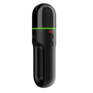
Leica BLK2FLY Autonomous Flying Laser Scanner
The Leica BLK2FLY is an autonomous flying laser scanner with advanced obstacle avoidance to facilitate reality capture from the sky. It captures building exteriors, structures, and environments to create 3D point clouds while in flight. The BLK2FLY is designed to be easy to use: with a few simple taps on a tablet, users can put the BLK2FLY in the air to autonomously scan building exteriors and features, including hard-to-reach areas like rooftops and facades. Deploying the device is as easy as unfolding it, turning it on with the press of a button, and placing it on the ground, ready for takeoff.
![]()
BLK2FLY Autonomous Flying Laser Scanner
- Enables scanning of hard-to-reach areas, such as building facades and rooftops
- Autonomously captures full scans of building exteriors to create 3D digital twins
- GrandSLAM sensor fusion of LiDAR, radar, cameras, and GNSS for complete scan coverage, optimised flight paths, and the shortest return-to-home
- Advanced obstacle avoidance for enhanced flight safety
- Hot-swap battery system
- Lightweight, portable, and easy to use
Users control the BLK2FLY through the BLK2FLY Live app on a tablet for simplified, app-based flight, without the need for prior UAV experience. This allows for easy and intuitive control of the BLK2FLY, including a live camera feed. You can select an area within the map on your tablet, and the BLK2FLY will create its own flight path to scan it quickly and safely. You can also tap to scan: simply send the BLK2FLY to scan a new area by tapping anywhere in the 3D view within the app.
The BLK2FLY Live app also allows you to pilot the BLK2FLY manually with virtual joysticks on your tablet. This critical safety feature keeps you always in control. For connectivity, the BLK2FLY includes WLAN and LTE communication channels to the tablet for a nearly unlimited communication range during flight.
The BLK2FLY makes it easy to bring your data into your preferred software and share your scans with others. It also works seamlessly with other Leica Geosystems sensors and software. You can directly upload your data to HxDR with automatic conversion to OBJ and cloud-based visualisation, and allow others to access and work with your data, including data downloads via HxDR. Alternatively, transfer your data to Leica Cyclone REGISTER 360 using USB-C or WLAN for scan-to-BIM workflows.
Autonomous UAV Exploration
The BLK2FLY intelligently incorporates the surrounding environment into its flight plans. It maintains the correct distance for an ideal scan and formulates optimised flight paths to return home.
Full Dome LiDAR Sensor
The onboard full dome laser scanner on the BLK2FLY captures 3D point clouds in all directions.
GrandSLAM
The BLK2FLY takes GrandSLAM technology even further. LiDAR SLAM, Visual SLAM, radar, and GNSS make the BLK2FLY fully autonomous, easy to use, and capable of flying on its own with safety and precision.
Full Scan with Advanced Obstacle Avoidance
BLK2FLY uses omnidirectional radar and LiDAR to avoid obstacles and perform precise, uninterrupted, and safe exploration.
Hot-Swap Batteries
The hot-swap battery system allows you to keep flying. The BLK2FLY will return to you during scanning to change batteries and then continue with its mission.
Portability
The BLK2FLY is lightweight (2.6 kg/5.95 lbs) and easily folds into a carrying case with all accessories.