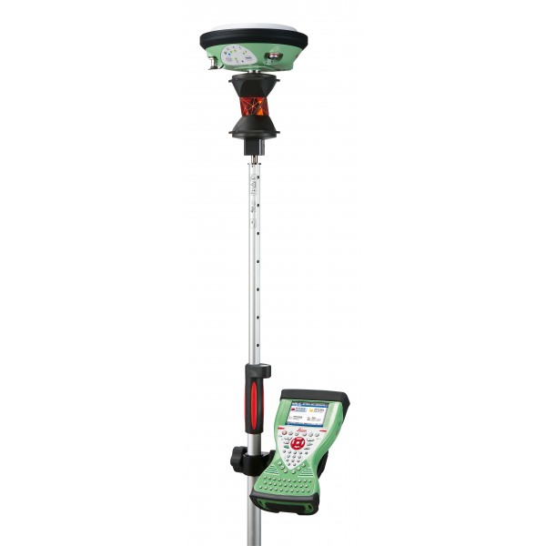
Leica SmartPole
The Leica Viva SmartPole is an innovative, high-precision solution for surveying data collection in the field. This system combines a telescopic pole with a GNSS (Global Navigation Satellite System) antenna and a high-speed radio modem to transmit data in real-time.
With the SmartPole, surveying professionals can capture precise data quickly and efficiently, resulting in increased productivity and project quality.
Work with total ease. Complete freedom to switch easily from GNSS to TPS.
Request more information
Leica Viva SmartPole
Leica SmartPole offers complete freedom of choice: you can easily switch from GNSS to TPS and vice versa. Measure every point with GNSS or TPS, or combine TPS and GNSS measurements quickly for TPS setups. Simply tap one of the icons and the SmartPole will switch immediately, giving you total flexibility for maximum productivity.
Simply move from GNSS surveys to TPS surveys:
TPS setup "on the fly"
- With SmartPole, set up on the go at the very moment you start the survey
- No need to measure orientation points first, saving time in survey planning and execution
Easy-to-use software
- Leica SmartWorx Viva features clear graphics, logical menu structures, and wizards to help with more complex procedures
- Non-technical terminology
- Pick it up, switch it on, and start working immediately
SmartAntenna ATX1230
The SmartAntenna incorporates GPS and GLONASS technologies and provides the maximum performance of SmartTrack+. Total flexibility of use with SmartPole, SmartStation, or SmartRover.
![]()
360° Surveying Prism
A high-performance, very lightweight 360° prism for use in high-precision measurements. The prism allows for the connection of a Leica SmartAntenna and is drop-resistant. It is the perfect reflector for the Leica SmartPole.
Connecting field and office
Conveniently combine data in the field or office via wireless LAN, USB, Bluetooth® wireless technology, 3.5G mobile broadband, and CF / SD cards.
Flexibility
It is no longer necessary to measure orientation points first and then measure detail points. With SmartPole, simply start the survey. If a point can be measured with both GNSS and TPS, this point can be used as an on-the-fly control point. Choose control points that offer the best geometric distribution while simultaneously completing the survey.
The location of control points often restricts where the TPS can be placed. With SmartPole, you can choose the most convenient location for the total station. Traversing is no longer necessary - every TPS setup can be performed independently with new coordinates and orientation determined with SmartPole GNSS.