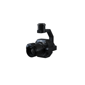
Zenmuse L2
10.818,00 € (Taxes not included)
Discover the revolutionary Zenmuse L2: Frame LiDAR, high-precision IMU, and 4/3 RGB camera.
Power your DJI flight platform with precise and efficient geospatial data. In combination with DJI Terra, obtain a comprehensive solution ready for 3D data collection and high-precision post-processing.
Request more information
Zenmuse L2 Aerial LiDAR System
The integrated LiDAR solution of the Zenmuse L2 allows for the precise scanning of complex targets with greater range and speed. During operations, users can preview, replay, and process point cloud models on-site. DJI Terra generates quality reports, offering a comprehensive one-step solution to improve efficiency. Achieve high-precision point cloud results with simplified post-processing.
- High Precision: Vertical precision: 4 cm; Horizontal precision: 5 cm
- Exceptional Efficiency: 2.5 square kilometres in a single flight
- Superior Penetration: Smaller laser spots, denser point clouds
- Detection Range: 250 metres at 10% reflectivity and 100 klx - 450 metres at 50% reflectivity and 0 klx
- 5 Returns
- All-in-one, ready to use
- Live view of the point cloud
- One-click processing in DJI Terra
Outstanding Precision and Efficiency
The Zenmuse L2 redefines precision with an exceptional combination of GNSS and proprietary IMU, achieving a vertical precision of 4 cm and horizontal of 5 cm. This level of detail guarantees high-quality results in data collection.
Efficiency reaches new limits, as the L2 is ready to operate upon powering up, collecting geospatial and RGB data across an impressive area of 2.5 km² in a single flight. This not only saves time but also improves overall operational effectiveness.
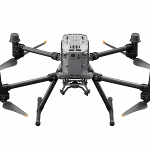
With its intuitive operation and compatibility with the Matrice 350 RTK and DJI Terra, the Zenmuse L2 offers a user-friendly all-in-one solution. This broadens access to this advanced technology, allowing more operators to leverage its capabilities without compromising ease of use.
Frame LiDAR: Enhanced Range and More Precise Points
Experience a 30% increase in detection range with the Zenmuse L2. With the ability to detect objects from 250 m at 10% reflectivity up to 450 m at 50% reflectivity, and an operational altitude of up to 120 metres, significant improvements in operational safety and efficiency are achieved.
Smaller laser spots, measuring 4x12 cm at 100 m, generate denser point clouds. This not only allows for the detection of smaller objects with greater detail but also facilitates penetration through dense vegetation and the creation of more precise digital elevation models.
The Zenmuse L2 stands out with the capability to support 5 returns, capturing more ground points even in densely vegetated areas. With an effective point cloud rate of 240,000 points per second in single and multiple return modes, the L2 provides an exceptional amount of point cloud information in a limited time. With two scanning modes—repetitive and non-repetitive—it adapts to various tasks, from high-precision mapping to power line inspection and forestry surveying.
High-Precision IMU System for Reliable Data
The Zenmuse L2 incorporates a self-developed high-precision IMU system, boosting data accuracy. In combination with the drone's RTK positioning system, the L2 accesses precise information on absolute position, speed, and altitude during post-processing, enhancing overall data quality.
With a real-time yaw precision of 0.2° and 0.05° in post-processing, as well as a pitch/roll precision of 0.05° in real-time and 0.025° in post-processing, the L2 ensures extremely accurate measurements. Furthermore, its IMU system requires no warm-up, offering optimised performance from the moment it is switched on.
The enhanced environmental adaptability of the IMU system increases the reliability and operational precision of the Zenmuse L2, ensuring consistent results even in challenging environments. This improvement not only optimises the on-site experience but also boosts the reliability of the collected data.
RGB Camera for Detailed Images and Authentic Colour
The Zenmuse L2 is equipped with a high-quality RGB mapping camera, featuring a 4/3 CMOS sensor and mechanical shutter. The increase in pixel size to 3.3 μm and an effective capacity of 20 MP result in a notable improvement in the overall imaging system, providing sharper details in point clouds with rich, authentic colours.
The reduction of the minimum photo interval to 0.7 seconds speeds up data capture, while the shutter capacity of up to 200,000 actuations contributes to operational efficiency by reducing long-term costs. The versatility of the RGB camera allows it to be used not only for point cloud collection but also for taking photos, recording videos, or generating visible light map images when necessary.
Unrivalled Operational Experience
Various Flight Route Types | Point Cloud Live View |
| Supports Waypoint, Area, and Linear route types for mapping tasks in a wide variety of environments. | During operation, DJI Pilot 2 allows for three display modes: RGB, point cloud, and side-by-side point cloud/RGB, to present operational results intuitively. By activating RNG (laser rangefinder), distance information between the LiDAR module and the object in the centre of the field of view can be accessed to increase flight safety. It also offers four modes for real-time point cloud colouring: Reflectivity, Height, Distance, and RGB. |
Replay and Merge Point Cloud Models | One-Click DJI Terra Processing |
| Upon completion of the operation, the 3D point cloud model can be viewed directly in the gallery. 3D point cloud models from multiple flights can also be merged to make on-site decisions regarding operational quality. | Achieve efficient and reliable one-step post-processing by importing data cloud information into DJI Terra. Generate a standard format 3D point cloud model with just one click after calculating the point cloud trajectory and optimising its precision. After classifying ground points using the Ground Point type, a digital elevation model can be generated. Point cloud quality can be analysed with the Accuracy Control and Review function. |
Automatically Generated Task Quality Reports | PPK Solution |
| After obtaining the point cloud information, the DJI Pilot 2 app will automatically generate a task quality report so that operators can check operational results in real-time on the ground, providing more responsiveness and peace of mind. | In complex operational environments, users can set up RTK base stations before operating to preventively avoid RTK data loss due to interference, video transmission disconnection, or other reasons. After the operation, import the original files into DJI Terra to use the PPK (Post-Processed Kinematic) process to reconstruct high-precision models. |
Versatility in Applications: Zenmuse L2 in Action
The Zenmuse L2, in collaboration with DJI Enterprise flight platforms and DJI Terra, offers exceptional performance in various scenarios. Its application extends to terrain inspection and mapping, as well as power, forestry, and infrastructure management.