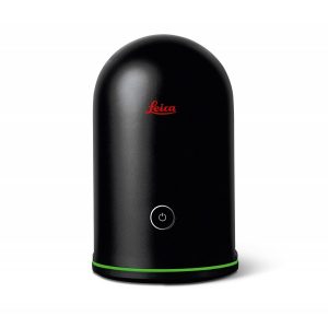
Leica BLK3D
Leica BLK3D 3D measurer.
The BLK3D combines a calibrated stereo camera, measurement sensors, software and integrated edge detection capabilities to perform image-based measurements with professional accuracy. Each captured image becomes a complete and precise 3D measurement record.
Request your quote:
Request more information
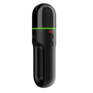
Leica BLK3D
Compact and complete photogrammetry tool from Leica Geosystems
The new Leica BLK3D 3D measurer offers the ability to perform 3D measurements on any photograph, in real time, with professional-grade accuracy. Every stored image becomes a new record on which any type of measurement can be performed. To achieve this, the BLK3D combines high-precision sensors, software and real-time data processing capabilities.
This new instrument, designed for multiple professional fields (Architecture, Design, Installations, Engineering, Surveying, Civil Engineering...), revolutionises the market by allowing users to measure inaccessible locations, create floor plans, estimate installations in buildings and document construction progress... any project you need to carry out will be within reach. It also allows automatic data transfer from the field to the office.
![]()
Real-time measurements on a photograph
The Leica BLK3D incorporates a powerful calibrated digital camera which, combined with advanced computer vision software, enables highly accurate measurements directly on images, as well as real-time data transfer to the office. Share images and measurements in multiple formats.
The art of photogrammetry, simplified
An outstanding combination of a calibrated camera, advanced algorithms and real-time edge computing, integrated with leading electronic distance measurement technology (EDM).
Progressive documentation projects for AEC
Capture key milestones throughout the lifecycle of a building in the simplest way.
Access your projects
From anywhere, at any time. Data is transferred directly from your hand to the office.
Object detection and snapping
Its auto-adjustment capabilities through computer vision technologies allow easy selection of key points for measurements.
Always work with digital plans
Create floor plans or import them, and combine them with measurable images.
Store, organise, share
All images stored on the device can be organised by projects, tagging each image with keywords for quick and easy retrieval. You can also share them in multiple formats.
BLK3D accuracy:
- EDM accuracy: 1 mm*
- 2D image accuracy: +/- 3 mm*
- 3D image accuracy: +/- 6 mm*
* Measurement accuracy and reliability depend on factors such as distance, object position, baseline length, object texture, lighting conditions, ambient temperature, calibration, etc.
The values stated are typical under favourable conditions at short range and are subject to change.