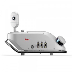



Leica Pegasus TRK700
Leica Pegasus TRK700. A unique scanner with 2 million measurements per second and a cross-line point cloud pattern.
Request more information
Leica Pegasus TRK700: Leica’s most powerful Mobile Mapping solution
The Leica Pegasus TRK700 redefines reality capture by enabling a complete and highly efficient workflow from field measurement to the production of 3D point clouds and digital twins. Thanks to its ergonomic design, latest-generation integrated sensors and intuitive software, it is the ideal choice for professionals seeking accuracy, agility and profitability in their projects.
Advantages of the TRK700
- High scanning speed and extreme detail: the TRK700 uses a dual scanner with up to 1,000,000 measurements per second and generates point clouds with a cross-line pattern, allowing environments to be captured with high information density and accuracy.
- Lightweight and manageable by one person: weighing just 23 kg and featuring a rotating platform with ergonomic mounting, it can be transported and installed by a single person — ideal for fieldwork, urban planning, construction monitoring or heritage projects.
- Optimised field-to-office workflow: supported by Leica Pegasus FIELD and Leica Cyclone Pegasus OFFICE software to plan missions, process data in real time, georeference and generate final point clouds — all with minimal manual intervention.
- Versatile use: suitable for multiple sectors: surveying, transport, infrastructure, utilities, education, BIM, heritage, smart cities… Suitable both for expert users and for those getting started in mobile mapping.
- Autonomy and robustness: it features lithium batteries with the option to extend autonomy and hot-swap batteries to prolong working hours; its robust construction is suitable for demanding environments, making it a reliable system for outdoor work, civil engineering sites or remote areas.
Efficient, error-free real-time data capture
Optimise data capture with Leica Pegasus FIELD, the solution that allows you to plan and execute projects with complete confidence. Thanks to its real-time visual and audio feedback, it eliminates errors during data collection. In addition, it predicts mission time, calculates the required storage and battery capacity, and provides live accuracy estimates. Ensure efficient, worry-free data acquisition with this innovative technology.
Agile mobile mapping with simplified mounting and operation
The Leica Pegasus TRK revolutionises mapping with a lightweight design and rotating mounting platform, allowing one person to mount and operate it safely. Its simplified use reduces the need for training, optimising costs and productivity without compromising performance. Thanks to its intuitive software, the process is streamlined from project planning to results delivery.
High accuracy for any experience level
Discover the Leica Pegasus TRK700, the ideal mobile mapping system for surveying, transport and utilities. Designed for both beginners and experts, it guarantees high accuracy and level of detail in the creation of digital twins. Perfect for long-range applications, this system redefines efficiency in mobile mapping.
Extended autonomy with safe batteries and hot swapping
The lithium-ion batteries feature a safe transport mode, allowing them to be shipped without risk and ensuring worry-free travel. In addition, autonomy can be extended up to 21 hours with three additional batteries and the hot-swap function can be incorporated, ensuring an uninterrupted power supply.